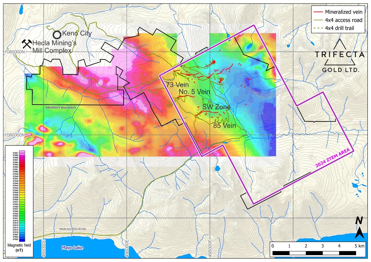
- Step-out drilling at the SW Zone – 950 m along strike from 2020 drill holes, which returned 6.44 g/t gold with 2.51 g/t silver over 12.14 m and 3.86 g/t gold with 182 g/t silver over 9.75 m.
- Shallow drilling at the parallel No. 5 Vein where 1980 drilling returned 128.91 g/t silver over 3.05 m, with no assays for gold.
- Airborne ZTEM and magnetic surveying, covering bulk-tonnage gold targets in the southern and eastern portions of the property.
- Detailed mapping, prospecting and research studies in partnership with the Yukon Geological Survey and Canadian Universities.
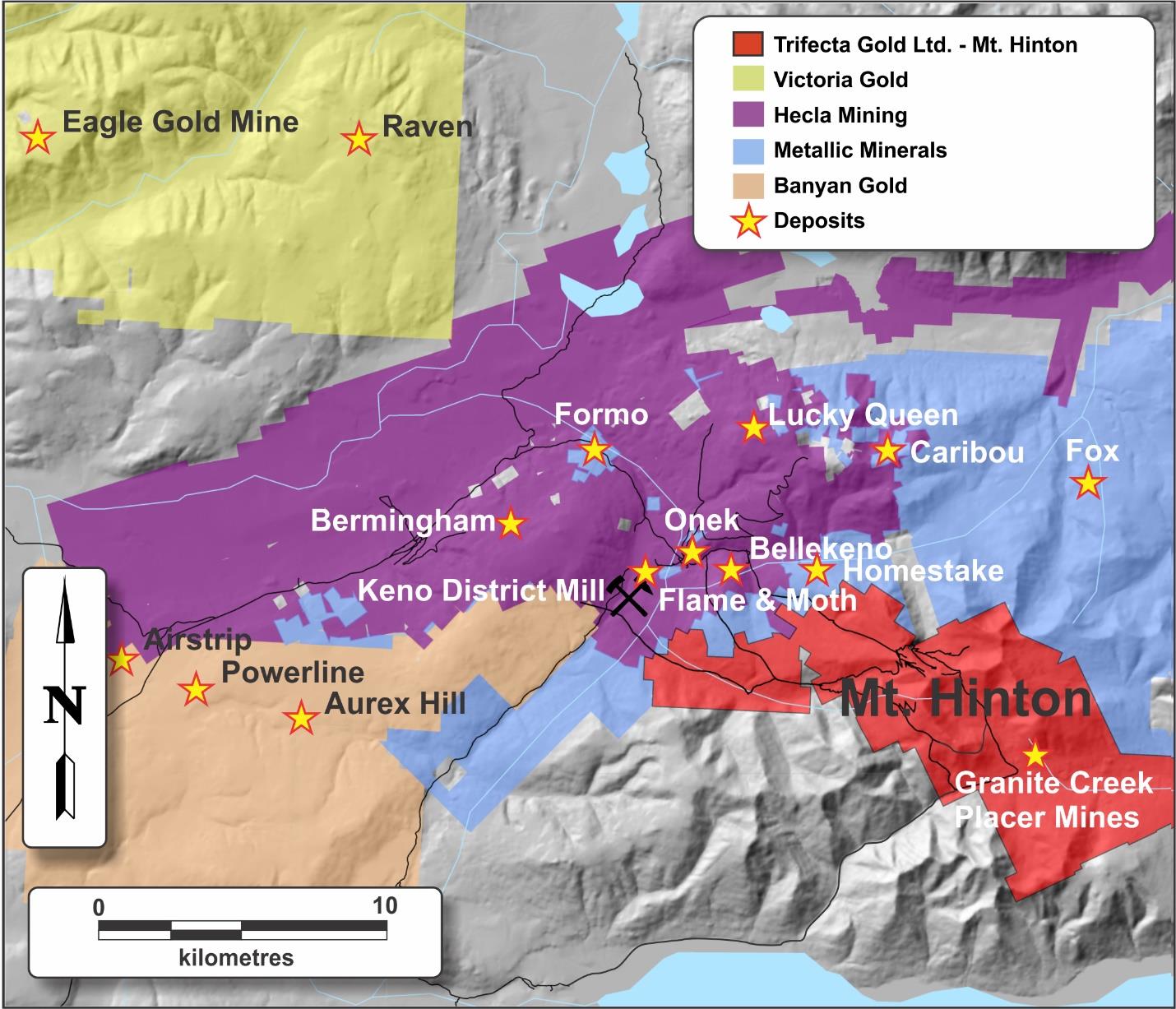
July 16, 2024 - Trifecta Gold Ltd. (TSX-V: TG) (OTCQB: TRRFF) (“Trifecta” or the “Company”) is pleased to announce that crew and equipment have been mobilized to its road accessible Mt. Hinton project, situated within the Keno Hill Mining District of the Tombstone Gold Belt. The Mount Hinton Project is located less than 4 km from Hecla Mining Company’s Keno Hill mill.
Trifecta has designed a multifaceted exploration program to: 1) further delineate known zones of mineralization through drilling, 2) make additional discoveries by following up on existing soil anomalies with detailed mapping and prospecting, and 3) expand the area of prospectivity by completing additional soil surveys combined with an airborne ZTEM (“Z-Axis Tipper Electromagnetic”) and magnetic survey.
Drilling
Trifecta plans to drill 1500 m at the SW Zone and No. 5 Vein. These parallel structures are located 700 m apart and have been traced on surface for 900 m and 420 m of strike, respectively, and over 200 m vertically. The SW Zone was successfully drilled by Strategic Metals in 2020, while the No. 5 was targeted by United Keno Hill Mines (“UKHM”) in 1980 and Mill City in 2011 by shallow, percussion drill holes. Importantly, despite identifying the presence of visible gold, UKHM did not assay for gold. 3-D modelling by Trifecta demonstrates that the vast majority of the historical drilling at No. 5 did not reach target depth. Previous results from these targets include:
Zone | Sample type | Hole or sample # | Gold (g/t) | Silver (g/t) | Width (m) |
SW Zone | Diamond drill | MH-20-22 | 6.44 | 2.51 | 12.14 |
SW Zone | Diamond drill | MH-20-18 | 3.86 | 182 | 9.75 |
SW Zone | Chip | B0050092 | 200 | 90 | 1.2 |
SW Zone | Chip | B0050094 | 80.3 | 72 | 1 |
SW Zone | Chip | W590630 | 30.5 | 53.1 | 1.2 |
SW Zone | Chip | B0050157 | 12.4 | 28 | 1.5 |
SW Zone | Outcrop rock | W590629 | 48.5 | 73 | n/a |
SW Zone | Outcrop rock | W590624 | 46.9 | 446 | n/a |
SW Zone | Outcrop rock | W590622 | 28.5 | 379 | n/a |
SW Zone | Outcrop rock | W590625 | 12.6 | 2,100 | n/a |
No. 5 Vein | Percussion drill | H-4 | n/a | 128.91 | 3.05 |
No. 5 Vein | Percussion drill | H-7A | n/a | 192.7 | 1.52 |
No. 5 Vein | Percussion drill | H-13 | n/a | 78.88 | 7.62 |
No. 5 Vein | Chip | B704049 | 3.04 | 85 | 2.25 |
No. 5 Vein | Chip | BB28344-346 | 1.04 | 92.5 | 4.20 |
No. 5 Vein | Float rock | 16367 | 17.14 | 1879 | n/a |
No. 5 Vein | Outcrop rock | B704048 | 8.27 | 63.9 | n/a |
Additional, nearby, road accessible targets will be tested based on drill productivity. These include the 85 Vein and the 73 Vein. The 85 Vein is marked by a 125 by 50 m area of quartz vein boulder float located roughly 400 m south of the highlight SW Zone drill intercepts. Quartz boulders (up to 1 m in diameter) hosting scorodite, arsenopyrite and galena were traced to the apex of a large float train. Four float samples were collected from this area, all of which returned greater than 5 g/t gold. The two best samples, taken approximately 15 m apart near the top the float train, returned 273 g/t gold with 284 g/t silver and 138.5 g/t gold with 57.5 g/t silver. The 73 Vein was discovered by soil sampling and is located 800 m north of the No. 5 Vein. It was intersected in a historical percussion hole which graded 31.7 g/t gold and 23 g/t silver over 1.52 m.
Airborne Geophysical Survey
A 440-line kilometre ZTEM and magnetic survey is scheduled to begin shortly. Flight line spacing will be 200 m with tie lines every 2,000 m. The survey is designed to cover the entirety of the Granite Creek basin as well as areas to the south and east that lie outside of the area of current geophysical coverage. These geophysical techniques have proven useful in highlighting alteration, structures and intrusive bodies elsewhere in the belt.
Mapping, Prospecting and Soil Sampling
Previous soil surveys have identified large areas with gold-in-soil results greater than 100 ppb that have not been systematically mapped or prospected. Notably, an open ended 1.5 km2 gold-in-soil anomaly located 2 km east of the SW Zone and within the Granite Creek basin is marked by a coincident magnetic low. Further south on the property and outside of the area of current geophysical coverage, there is an area containing many anomalous soil samples that were collected on widely-spaced, contour-controlled sample lines. Large, highly productive placer mining operation are located directly downhill from both of these geochemically anomalous areas.
Geological mapping at Mt. Hinton will be performed as part of a planned, multi-year research program in the Keno Hill District, undertaken by the Yukon Geological Survey, Simon Fraser University, the University of Alberta and partner companies. This work is intended to better characterize the styles of mineralization at Mt Hinton and other projects within the Keno Hill District and to determine its context within the broader Tombstone Gold Belt.
About Mt. Hinton
Mt. Hinton is a road accessible, camp-scale property with over 60 precious metals veins identified to date. The project is underlain by direct extensions of the stratigraphy that hosts Hecla’s Keno Hill Mines and, because of this, much of the historical exploration at Mt. Hinton focused on its silver potential. Surprisingly, historical workers largely overlooked gold potential, despite visible gold that has been found in many of the known veins. Many bonanza grade (>100 g/t gold) assays have been reported from surface grab and chip samples:
- September 9, 2019, Strategic Metals Discovers More Gold-rich Veins at Its Mount Hinton Property, Yukon (includes a 202 g/t gold grab sample in Granite North)
- January 23, 2023, Strategic Metals Discovers New Veins at its Mt. Hinton Gold-Silver Project, Yukon (85 vein float samples grade 273 g/t gold and 138.5 g/t gold, outcrop sample from 15 vein grades 126.5 g/t gold, 19 vein float sample returned 101 g/t gold)
There are active placer mines on the creeks draining in all directions from the property. Based on metal zonation within the district and the regional magnetic signature at Mt. Hinton, a reduced intrusion on the property is theorized to be the driver for much of the mineralization in the district. Many recently identified gold-in-soil anomalies have yet to be prospected and a large magnetic low in the southeastern part of the project has not been investigated. Both are priority targets for Trifecta.
Tombstone Gold Belt
Extending for more than 1000 km from the Fairbanks district in Alaska eastward across the entire width of Yukon, the Tombstone Gold Belt hosts many large Reduced Intrusion-Related Gold System (RIRGS) mines such as Fort Knox in Alaska (>10 million oz), Eagle and Olive in Yukon (>4 million oz) and the past-producing Brewery Creek Mine, also in Yukon. Since May 2020 over 17 million additional ounces of gold have been discovered in the Yukon portion of the belt, including Snowline Gold’s Tier 1 Valley discovery, Sitka Gold’s RC deposit, Banyan Gold’s AurMac deposits and Victoria Gold’s Raven deposit.
Tombstone Gold Belt systems are characterized by sheeted, auriferous quartz veins forming in the carapace zones of Cretaceous-age plutons. They have a characteristic geochemical signature with a gold-bismuth-tellurium±tungsten core within a broader gold-arsenic halo. The deposits are found within and surrounding the reduced intrusions, and typically exhibit a geophysical signature comprising a magnetic low (ie. reduced) coinciding with at conductivity low. Veining in RIRGS systems is typically zoned with a core of sheeted veins surrounded by more discrete gold-arsenic veins and more distal silver-lead-zinc veins.
Technical information in this news release has been approved by Trifecta’s Vice President, Jackson Morton, P.Geo., a qualified person as defined under the terms of National Instrument 43-101.
About Trifecta Gold Ltd.
Trifecta is a Canadian-based precious metals exploration company dedicated to increasing shareholder value through the discovery and development of 100% held gold projects in Yukon and Nevada. Trifecta has secured an option to acquire a 100% interest in Mt. Hinton and 10 other highly prospective, intrusion-related gold projects located in Yukon’s Tombstone Gold Belt where over 17 million ounces of gold have been discovered since May 2020. Initial drilling at the Company’s Yuge Gold Project, located in northern Nevada, has identified multiple broad zones of gold mineralization near historical high-grade mines. The Company’s Eureka Project hosts an 8 x 2.5 kilometre belt of surface showings and anomalous gold-in-soil that straddle the headwaters of two of the most productive placer creeks in Yukon’s southern Klondike Goldfields. Trifecta’s Treble Project covers a large hydrothermal system, located midway between Western Copper and Gold Corporation’s Casino Deposit, the largest copper and gold deposit in the Yukon, and Rockhaven Resources Ltd.’s Klaza Deposit, a high-grade gold-silver deposit.
ON BEHALF OF THE BOARD
“Richard Drechsler”
President and CEO
For further information concerning Trifecta or its various exploration projects please visit www.trifectagold.com or contact:
Corporate Information
Trifecta Gold Ltd.
Richard Drechsler
President, CEO & Director
Tel: (604) 687-2522
This news release may contain forward looking statements based on assumptions and judgments of management regarding future events or results that may prove to be inaccurate as a result of exploration and other risk factors beyond its control, and actual results may differ materially from the expected results.
Neither the TSX Venture Exchange nor its Regulation Services Provider (as that term is defined in the policies of the TSX Venture Exchange) accepts responsibility for the adequacy or accuracy of this news release.


